
Springborn Dam
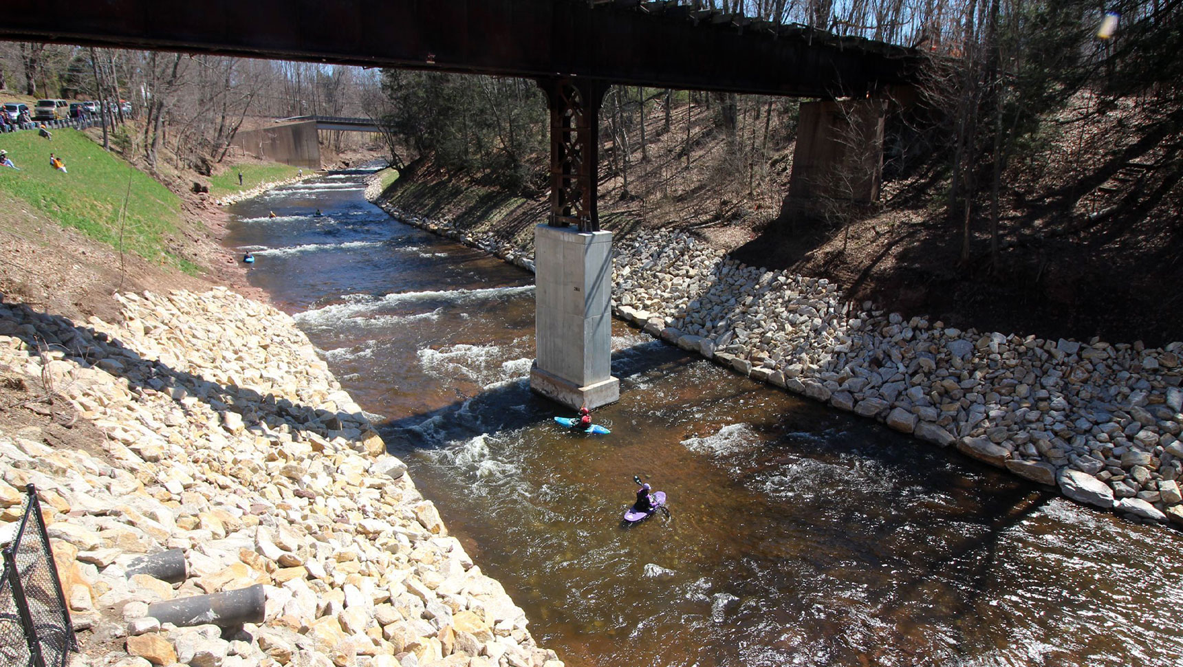
Springborn Dam, a 25-foot-high stone masonry dam, was originally constructed in 1840 and was used in the early 19th century to power machinery at an adjacent mill. The dam has undergone reconstruction and modification several times, and has been deteriorating for decades due to lack of use and maintenance. The dam was in such poor condition that catastrophic failure was a possibility. The deteriorated dam presented an obstacle to fish passage on the Scantic River, limited natural cold-water fisheries, and limited recreational access such as canoeing and kayaking.
Our client, the State of Connecticut Department of Energy & Environmental Protection (CT DEEP), is committed to restoration of rivers to their natural state wherever feasible. Removal of this high hazard dam would reconnect 2.6 miles of upstream fish habitat, restore natural riverine functions, increase community resilience in the face of future storms, remove risk of damage to downstream property, and eliminate a public safety risk.
The dam removal was funded by a U.S. Fish and Wildlife Service Hurricane Sandy Resiliency Grant Program. Coordination with both the adjacent mill building owner and the Connecticut Department of Transportation (CTDOT) were integral components to project success.
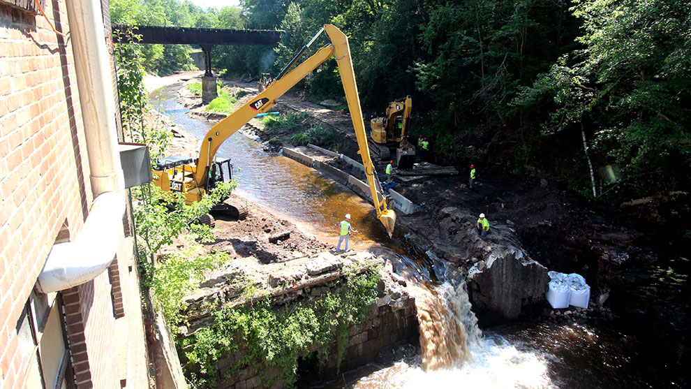
Springborn Dam was topped with six feet of timber cribbing and was located in a bedrock gorge with very limited accessibility. Our multidisciplinary team helped overcome many significant challenges during the project.
Major concerns regarding dam removal were cost and environmental impact from construction activity and contaminated sediment trapped behind the dam. Fuss & O’Neill provided a complete feasibility analysis and dam removal design with in-house capabilities, including hydrologic and hydraulic engineering, wetlands and sediment quality and permitting expertise, geotechnical engineering, and structural engineering. Impact of the dam removal on an upstream drinking water well field was assessed to ensure that there would be no substantial reduction in availability of potable water. Fuss & O’Neill also provided full time construction oversight, documentation, and design interpretation services during construction.
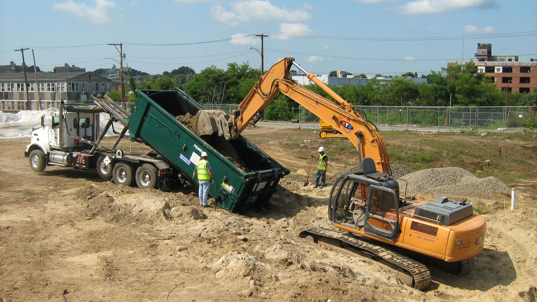
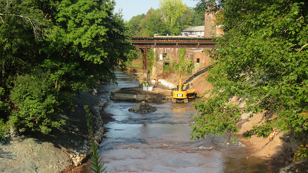
A major construction problem with removing the dam was the extremely limited access to the dam, which abutted the mill building on the south side. No legal access from the north side was available. Therefore, all work needed to be performed in the water. Extensive sub-surface investigations, including mechanized drilling into the river channel from a floating platform, and underwater inspections to sample sediments were provided.
Fuss & O’Neill designed and permitted temporary access roads to the riverbed from the steep upstream south embankment. A temporary crushed stone road was designed in the riverbed for construction equipment to access the dam from a point a quarter-mile downstream of the dam, including design of a temporary crossing over a tributary to the Scantic River. Following construction, all temporary in-river access roads and the temporary stream crossing were removed. The steep embankment slopes were stabilized with stone armor.
Fuss & O’Neill’s provided hydrologic and hydraulic (H&H) engineering as part of dam removal design. Our team examined the feasibility of options for dam removal, such as full removal, partial removal, and full restoration of the original dam. They used the latest HEC software to model base and flood flows for the river. With the results of their modeling, potential downstream impacts of dam removal were analyzed.
Our engineers designed a critical temporary access road into the impoundment to allow removal of dam materials and significant contaminated sediment volumes; designed a scour wall to protect the mill building; designed riverbank protection; designed scour protection for the downstream railroad pier located in the center of the channel; designed scour protection for the downstream Route 191 bridge; and designed reconstruction of the river bottom with change of grade structures if they were found to be necessary. Sediment mobility was studied to assess the potential for sediment to collect downstream and form natural barriers to river flow.
During construction, Fuss & O’Neill engineers coordinated dam removal activities with the water levels in the upstream Somersville Pond Dam, using the upstream pond to help control storm flows to Springborn Dam during construction/ They also coordinated water control with a CTDOT large-diameter culvert replacement project at the Terry Brook crossing of Route 191 and with a mill building demolition project adjacent to the Scantic River upstream of Springborn Dam.
Fuss & O’Neill’s geotechnical engineers performed an investigation of sediment depths, as well as an investigation of the footing depth and type of the downstream railroad center pier located in the middle of the dam impoundment. The sediment depth investigation was performed using a modular barge with a skid-mounted drill rig, stabilized with cables at both the north and south embankments. Sediment depths were obtained to quantify the sediment volume and collect samples for grain size testing and sediment quality testing. The results indicated that approximately 12,500 CY of sediment would need to be removed for full dam removal.
During construction, the river was dewatered and Fuss & O’Neill’s geotechnical engineers oversaw a test pit adjacent to the railroad central pier to ascertain the type of pier foundation and whether the footing was founded on bedrock. This data was to be used by Fuss & O’Neill’s H&H engineers to evaluate the scour potential around the pier under proposed dam removal conditions. The results indicated that the central railroad bridge pier was founded on a rock and soil-filled timber crib, and the crib was founded on bedrock.
Based on our observations, Fuss & O’Neill determined the pier had deteriorated and was not stable, and either a new foundation would be needed to support the pier, or the pier would need to be replaced in its entirety. CTDOT directed CTDEEP to design and replace the pier as part of the project.
Structural services in support of this project included design of a scour wall to protect the mill building adjacent to the river and repairs to an existing CTDOT railroad bridge concrete pier in the Scantic River just upstream of the dam. Our structural team designed a new railroad bridge pier and developed a method to support the bridge during demolition and construction. We collaborated closely with CTDOT Rails, CTDEEP, and the contractor to design and permit the new pier on an expedited basis within the original design and construction services budget.
The railroad bridge presented problems due to its legal standing as an active rail line (although it had not been used in decades and was severely deteriorated), and because it supported an 18-inch diameter jet fuel pipeline crossing the Scantic River. Because dam removal would scour the deteriorated center bridge pie foundation, Fuss & O’Neill’s structural engineering staff expedited the demolition of the old pier and design of a new pier.
The existing bridge needed to be supported during pier replacement with almost no movement of the fuel pipeline (the active petroleum fuel pipeline could not be moved more than ¾” vertically or horizontally), so Fuss & O’Neill’s structural engineers designed a pair of temporary support towers to support the bridge on either side of the center pier to be removed. The temporary supports consisted of 40’ tall steel towers in the river on each side of the pier that were slid into place on temporary concrete pads. The bridge was jacked 1/8” vertically to relieve the load and reconstruct the pier, then lowered back to its original position on the new pier, with no adverse effects on the pipeline or bridge. The footing for the temporary towers consisted of poured concrete on the existing bedrock, requiring multiple diversions of the river. The new pier was constructed while the river was diverted to both sides of the construction, and the settlement of the bridge following removal of the temporary support towers was negligible.
Fuss & O’Neill collected sediment samples in the river behind the dam and at suspected outfalls from the mill building and found there were chemical contaminants exceeding allowable concentrations of heavy metals, PAHs, and chlorinated pesticides. During construction, sediment was excavated and stockpiled in the riverbed while fast-track testing was performed to determine acceptable disposal sites for the polluted sediment, which was then trucked directly to approved disposal facilities. This was accomplished without causing delays in the construction.
Additionally, based on the sediment volume and contamination levels, Fuss & O’Neill’s wetland scientists and biologists performed a toxicity study to assess the consequences if the contaminated sediment was allowed to move downstream following dam removal. The results indicated that unacceptable impacts to fauna and flora would occur if the sediment were not removed prior to dam removal.
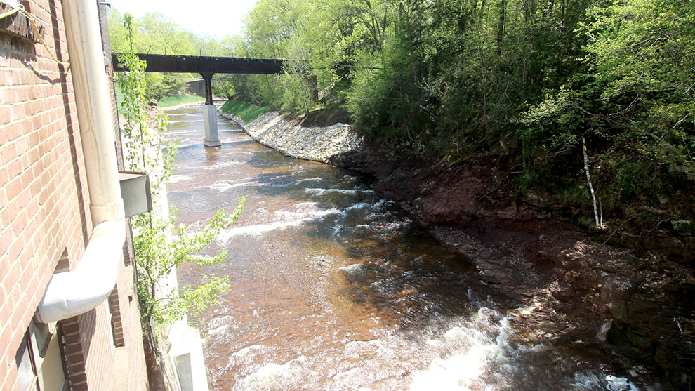
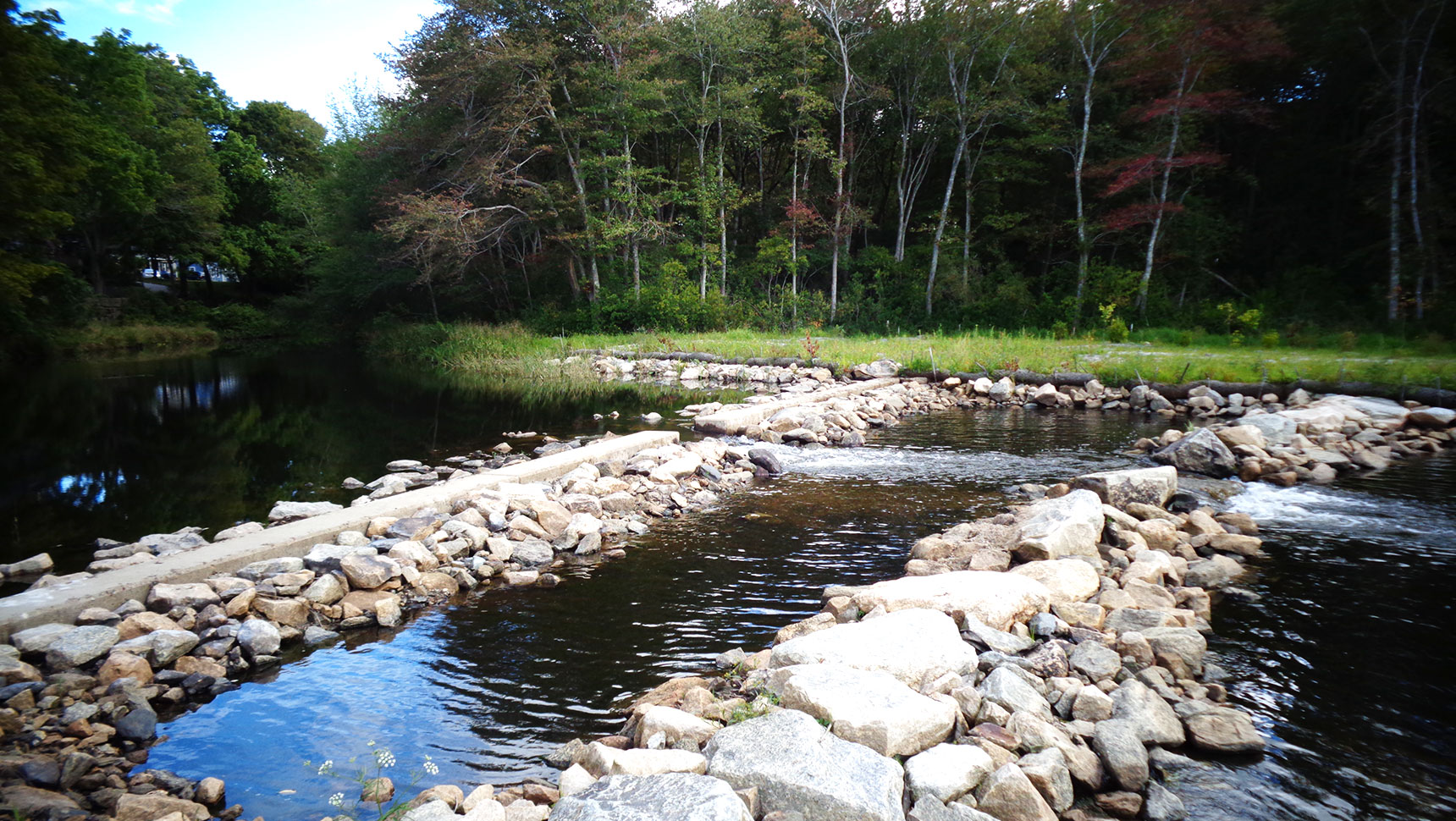
The project was a complete success. The dam was removed to existing bedrock with virtually no contaminated sediment moving downstream, and monitoring has shown no significant scour of downstream structures or the existing mill building. The center pier of the railroad bridge is stable, and the jet fuel pipeline is active is safer than it was previously.
Fish passage has been restored, and the stretch of the Scantic River interrupted by the dam now allows cold water fisheries and unobstructed canoeing and kayaking opportunities, including an annual canoe race. Lowering the water levels around buildings, bridges, and other infrastructure improved the ability of the community to respond and adapt to storms. Reconnecting fish habitats strengthened the natural ecosystem by extending these runs to geographic areas from where they have been absent for over 100 years, thus also increasing species’ population size.